Kyros Location services applied to Firefighting Planning and Prevention

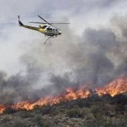
Forestry fires often occur in hard-to-reach places, where there is little or no telecommunications coverage; all this makes more difficult perform extinction services.

La lucha contra los incendios tiene sello de Kyros Localización

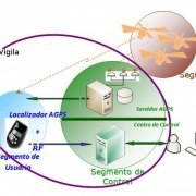
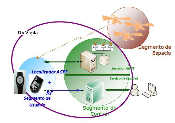
Spain is an especially sensitive country to fires mainly during the summer period. However, emergency officers and firefighters have access to a 100% Spanish technology. It is Kyros Location, based on a personal GPS device that significantly improves GPS signal acquisition and allows location in rural areas with problems of coverage, ensuring that agents can know their position more accurately in case of emergency.

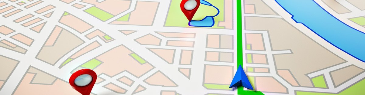
Police, fire brigades, emergency and rescue teams, health unit and environmental services may be able to issue an alert/warning – for example, panic. This alert indicates their location with high precision and helps their colleagues to support them or informs them that area it will be abandoned.

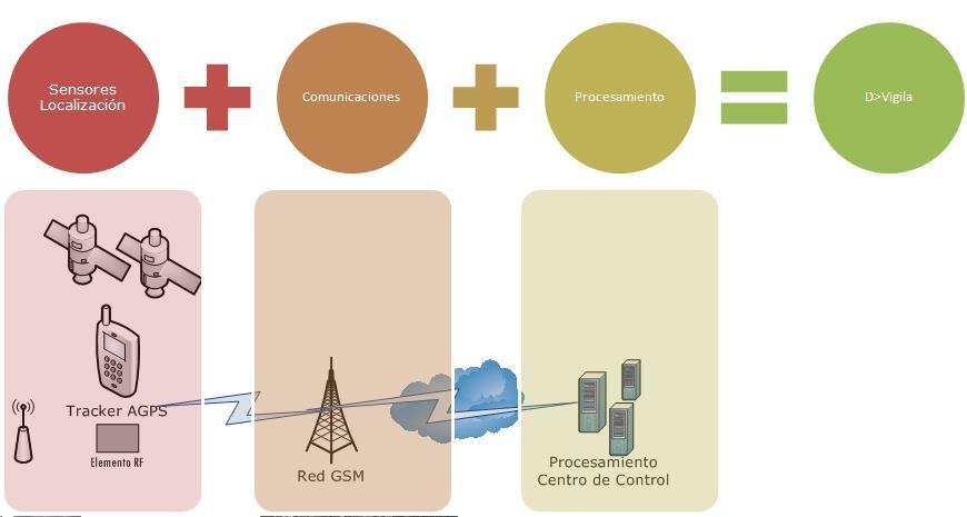
This GPS device, developed by Kyros LBS, is installed in vehicles or is carried by personnel themselves. Kyros platform receives real-time information about the location of agents and vehicles.

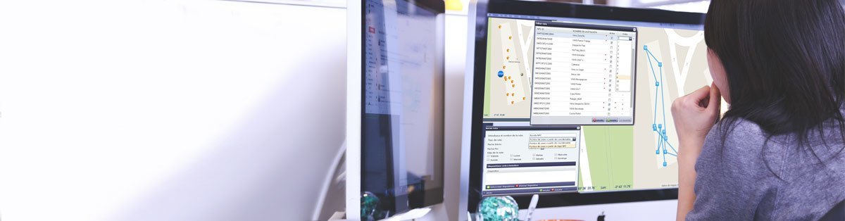
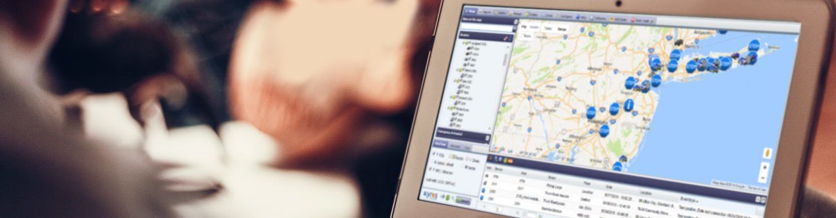
It allows control centres monitor and manage operational resources and emergency. Certainly, real-time information of location of emergency services and their movements around the fire area is essential to ensure fire extinction in the end.

GPS device developed by Kyros LBS is not only very useful in firefighting, but also in preventive and inspection tasks.

More than a conventional GPS, Kyros Location device is able to know precisely where the rescue vehicle or the team is. It is resistant to vibration, impacts and splashes; it is also designed against extreme environments without losing its function (real-time location). Furthermore, it should be small so that forest officers, firefighters or health personnel can carry it easily. It cannot only be used in the declared fire, but also in preventive and surveillance tasks after the fire. All information around the preventive firefighting services, itineraries of teams and vehicles, is essential to determine accurate Geofencing areas and calculate the burned and affected areas for further treatment.

The system has the following operation: it collects all data received by working teams and determines the burned areas and remaining areas that must be covered by the rescue campaigns. The different areas are marked with colours: blue, areas tracked by a single officer; turquoise, where several officers have tracked, so it is considered the whole area has been totally covered.

Kyros Localización análisis de zona batida por cuadrilla de rescate   Kyros Localización tracking de personal de rescate

Kyros platform: Geofencing tests based on firefighters and rescue teams techniques.

Numerous government agencies and Spanish institutions use this Kyros solution to locate their teams, officers, helicopters, trucks, pumps …, that belong to their firefighting equipment. Each team or vehicle requires a customized monitoring, and Kyros allows this customization in order to prevent erroneous data. For sure, it is an essential tool to improve safety of officers, firefighters and pilots. At the same time, it provides vital information to know, in real time, how firefighting tasks are being performed.


“A new way to build on Europe ” – Deimos Space concludes successfully d>Vigila project

Deimos Space concluye con éxito el proyecto d>Vigila

The development of this Project has been possible thanks to the financing of Ministry of Innovation and Science (National Plan of Scientific Research, Development and Innovation) and the European Community through the European Fund of Regional Development (FEDER)

Deimos Space concluye con éxito el proyecto d>Vigila

Deimos Spaces’ unit specialized on location technologies has concluded d>Vigila Project focusing on these three main scopes:

  1. Provide location services to vulnerable people due to own personal situation (old people, Alzheimer patients, children, hikers…)
  2. Guarantee protection and security of risk groups (gender-based violence, prisoners….)

On a technical level, d>Vigila is an ambitious project that searches  the interrelationship of three technological areas in order to define a series of location services to improve the life quality of the previous mentioned groups.

Deimos Space concluye con éxito el proyecto d>Vigila

The main research areas of d>Vigila Project is the following ones:

  1. Analysis of real needs, associated to people location in defined environments.
  2. “Integrating” different location technologies (GPS, aGPS, RFId) in a new personal device, which could provide person location even indoors with enough accuracy to withstand critical environments.
  3. Assisted GPS Server (aGPS Server) that enables these devices to obtain real position even inside facilities, as well as improve considerably starting and acquisition time.
  4. Control Centre is the platform in charge of receiving information from devices. It is responsible for analysing data, storing them and supporting related services (displaying and real-time monitoring of people who carry the devices on the different cartographies, studying and analysing the activity history routes, managing of emergency or alarm cases, as well as exchanging data with other platforms that belong to emergency services in case of accident or danger situation….)

Following  graph represents the architecture of the platform itself.

dvigila4


dispositivos con tecnologias avanzadas

KYROS INTEGRATES ADVANCED TECHNOLOGIES DEVICES

Kyros 6.0 integrates advanced technologies devices for Mobile Personal telemetry and Assets and Vehicles telematics. 

The new devices with advanced technologies integrated on location-based platform Kyros 6.0 enables tracking of items such as:

  • Cargo containers
  • Waste removal for clearance services,
  • Delivery packages,
  • Vehicles telematics new CAN bus and OBD parameters,
  • Personal monitoring sensors,
  • Personal devices for electronic monitoring of restricted mobility personnel and other Public Safety applications (Domestic violence offenders, House Arrest, Parole and Probation and Other Public Safety applications )
  • Personal telematics for remote Health & Care services.

The personal telematics functions of Kyros 6.0 include a new algorithm for calculating and representing levels of autonomy of the devices. In portable devices, the battery indicator is considered a “critical event”; therefore for a more precise control of this factor, Kyros 6.0 includes this event in the real-time report of the location of assets and people.

kyros_lbs_kyros6-0_dispositivos3

modulo de soporte y notificación de incidencias al usuario

USER SUPPORT AND LIVE NOTIFICATIONS MODULE

One of the main improvements of new version of Kyros 6.0, is the Kyros-web desk live notifications module for customer service support. To provide a better supporting, monitoring and assistance service to our users Kyros 6.0 includes in its interface a new tab that allows reporting user issues immediately our Logistics team. The user receives notification of issues registration, opening and resolution and a status report.

This support module allows us to improve response times, speed up communication and resolve issues with our users and customers faster.

Kyros new contact channel added to its online email and telephone support contacts lines. 

modulo de soporte y notificación de incidencias al usuario

registro y alta de nuevas flotas

KYROS NEW FLEET SET-UP DIRECTORY

Kyros 6.0 improves new fleet set-up directory adding new fleet profile upload functions.

The new multi panel directory structure allows faster and agile fleet registration process. Also fleets directory structure indexes fleets according to customer’s jobs or country structure.

Kyros 6.0 release also adds new upload setting that allows a bulk upload grouping a large list of Kyros system entities such as of fleets, users, drivers, as well as POIs and categories and setting them up on the Kyros Company’s profile in a single-upload.

Registro y altas de nuevas flotas

Monitorización de agrupaciones

GROUP MONITORING – VEHICLES FLEET OR WORKERS TEAM TRACKING

Kyros 6.0 includes very useful “group monitoring” function to track the workers team or vehicles fleet activity assigned to specific job, project, department or even a specific province or area.

Kyros 6.0 includes the automatic display of all the managed devices associated to a Job Manager, so the user or manager will check a map view of all the resources associated to his Kyros access-profile. This quick map view of all job or team devices also have new search function allowing the manager to search by driver, type of equipment or nearby devices.

Monitorización de agrupaciones

Creación estructura multinivel para la agrupación de dispositivos

GROUP OF VEHICLES OR WORKERS DEVICES MANAGEMENT

Kyros 6.0 offers a multipanel directory structure that sets a group of vehicles or workers devices allocated by regions, projects, specializations, work teams, or any other criteria related to customer’s business organization.

To look up for information without digging in to paperwork Kyros 6.0 interface includes very useful group monitoring function to check where are all the vehicles or workers associated to a fleet or team jog or region.

Kyros 6.0 includes the automatic log-in display of all the managed devices that shows the status of all the resources associated to a fleet or devices group assigned to a Kyros web-access user profile.

ESTRUCTURA MULTINIVEL PARA AGRUPACIÓN DE DISPOSITIVOS

Optimización y mejora del módulo de gestión de rutas

ROUTE MANAGEMENT OPTIMIZATION

ROUTE MANAGMENET OPTIMIZATION

The optimization and improvement of the route management module is another innovation of the Kyros 6.0 version. Customers with mobile resources deployed throughout the world will be able to better track the routes of their assets, through:

  • Schedule time by each beacon,
  • Add new destinations between two points of the route,
  • Real-time notification during route and
  • Arrival and delays notices on-route tracks.

Optimización y mejora del módulo de gestión de rutas

Nuevos informes específicos por sector para análisis de actividad

NEW REPORTS FOR DATA ANALYSIS OF BUSINESS TASKS

Kyros 6.0 also includes specific reports by industry or business activity analysis: New reports include vehicles or workers activity by zones, routes and quarterly comparison of vehicles’ real consumption. The Kyros 6.0 reports have been optimized for editable formats in XLS, CVS and PDF.

Nuevos informes específicos por sector para análisis de actividad

API para interconexión con aplicaciones de terceros

KYROS API FOR THIRD PARTY APPLICATIONS

KYROS API for third-party applications transfer data and connect to other customers management applications.

The ERP, CRM and different management applications of our customers, can receive data from Kyros quickly and easily without the need for plug-ins, developments or extra HW, through the new Kyros API.

API para interconexión con aplicaciones de terceros