Funcionalidades Kyros - Idioma Ruso

NEW LANGUAGE: RUSSIAN

The solidity, reliability and security of our KYROS located-based platform give us the opportunity to expand our business to Eastern Europe. This has been the first step to deploy our platform in the Russian language, so we can have the opportunity to give support and offer our services to countries located in this area.

Nuevo Idioma: Ruso

Figure 1: Kyros Main menu

Nuevo Idioma: Ruso

Figure 2: Kyros Reports

This new scope enables us to try out integration of new devices, which are consistent with GLONASS [ГЛОНАСС, ГЛОбальная НАвигационная Спутниковая Система]. This is a space-based satellite navigation system operating in the radio navigation-satellite service (GNSS) and used by the Russian Aerospace Defence Forces.

Nuevo Idioma: Ruso

Figure 3: GLONASS constellation

Funcionalidades Kyros - Conducción Eficiente

ENERGY-EFFICIENT DRIVING

KYROS incorporates new devices that make customers control and manage the driving mode of their fleets and vehicles. It reduces CO2 emissions, as well as saving in fuel consumption up to 15%. Consequently, end-of-life of a vehicle extends.

In KYROS customers can check some vehicle features such as engine revolutions, fuel consumptions, travelled distances and routes…. Once all this information is processed by the system, users will be able to receive notifications of accelerations, braking, abrupt turn, over-revolutions, emergency stop,….

Here are some guidelines in order to improve driving mode and save costs.

  1. Ignition and starting of vehicle:
    • Start the engine without stepping on the gas pedal.
    • In gasoline engines, it is important to start just immediately after ignition.
    • In diesel engines, wait few seconds before starting.
  2. Go first gear:
    • Only use first gear at the beginning of start; then change to the 2nd after 2 seconds or 6 meters approximately.
  3. Acceleration and gear switching:
    • According to revolutions:
      • In gasoline engines: between 2.000 y 2.500 RPM
      • In diesel engines: between las 1.500 y 2.000 RPM
    • According to speed:
      • Switch to second gear: after 2 seconds or 6 meters.
      • Switch to third gear: from 30km/h approximately.
      • Switch to fourth gear: from 40km/h approximately.
      • Switch to fifth gear: over 50km/h.
    • Accelerate after switching gear.
  4. Gears use:
    • Drive as much as possible using high gears and low revolutions.
    • It is advisable to drive in high gears stepping firmly the gas pedal than in low gears with the gas pedal not firmly pressed.
    • In cities, use fourth or fifth gear whenever possible.
    • The vehicle consumes less fuel in high gears and low revolutions. For example, a small engine capacity (1, 2 litters), driving at 60 km/h:
      • In third gear, it consumes 7, 1 litters gasoline.
      • In fourth gear, it consumes 6, 3 litters (11% less).
      • In fifth gear, it consumes 6 litters (15% less).
  5. Running speed:
    • Maintain your speed as constant as possible; looking for flow traffic, avoiding braking, accelerations and unnecessary switching changes of gear.
    • Moderate speed: fuel consumption increases in terms of speed squared. Speed boost up to 20% (going from 100 to 120km/h) means an increase of 44% in fuel consumption (from 8 litters/100 km to 11.5 litters/100 km).
  6. Deceleration:
    • Lift foot off gas pedal and leave vehicle running with gear switched at that moment.
    • Brake softly with brake pedal.
    • Reduce gear as late as possible, specially descending.
  7. Turning off:
    • As long as speed and distance allows, it is important to turn off the vehicle without reducing gear previously.
  8. Stops:
    • In long stops (over 60 seconds), it is advisable to stop de engine.
  9. Anticipation and foresight:
    • Always drive leaving security distance between vehicles and maintain a field of vision enough to see two or more vehicles ahead.
    • As soon as we detect an obstacle or speed traffic reduction, lift foot off gas pedal to anticipate for special manoeuvres.
  10. Security:
    • Mostly, applying efficient eco-driving guidelines contributes to increase road safety.
    • Obviously, some circumstances require different specific actions, so security is not affected.

Moreover, ¡driving with any gear, without pressing gas pedal, over 1.500 revolutions or at 20 km/h, there is no fuel consumption.

Funcionalidades Kyros - Perfil de Altitud

NEW ALTITUDE PROFILE

This new functionality provides benefit for customers. KYROS has incorporated a new element, altitude, in each tracking location managed in the system. Users can choose this option for any of the devices registered in the platform.

It is especially useful for people who practice open-air sports: cycling, athletics , hiking…


NUEVO PERFIL SELECCIONABLE DE ALTITUD

REPORT USE OF THE VEHICLE PROFESSIONAL AND PRIVATE MODE

Reports of vehicle use with data and consumption in private and professional mode

Kyros processes data to generate vehicle usage reports that collect the distance traveled (KM or Miles), fuel consumption and hours of activity for a vehicle differentiating the private and professional mode.

  • How many km / consumption for a car model regardless of its driver?
  • How many kms for a driver regardless of his car?
  • How many kms / consumption for a driver in private mode and how many in professional mode?
Informe de Uso del Vehículo

Reports of Kyros LBS vehicle use by driver, in private and professional mode. Summary Consumption, Distance (KM or Miles) and Hours of Activity.

In the vehicle use report, Kyros processes the positions, and for each category of data: distance, consumption, and hours of activity, calculates the totals per driver in private and professional mode, in the period – week or month – selected.

EVENT NOTIFICATIONS

To activate notifications, Kyros receives and processes the data of the devices by associating them with events, which the web operator / user can manage according to their criticality and protocol.

Events such as: Unauthorized Movement, Stop at Point of Interest (POI), Proximity to Prohibited Zone, Excessive Speed, etc. Event notifications can be configured to be displayed on screen following the same protocol of action in case of Alarm or in the form of a Push message, SMS and / or email. All these events and notifications will be collected in reports for registration and subsequent treatment

Notificaciones de Eventos de Dispositivos conectados a Kyros


Event management is configured based on the query, notification and type of events or State, if it is critical – it is Alarm – if it is not critical – it is Alert, and it has an associated Notice or Notice. Alarms are treated in the interface by changing the device status: devices in normal situation, devices in emergency and devices in alarm. In an emergency situation, the platform receives the alarm and Kyros notifies the operator / user or Security Manager to verify its status and validate the change of status of the device.

MANAGEMENT OF CARTOGRAPHIES AND GEOGRAPHICAL INFORMATION

Gestión de Cartografías e Información geográfica de los servicios de Localización Kyros

Informes por gestión de conductores

DRIVER REPORTS

Informes Actividad de Flota por Gestión de conductor

ecall Sistema de Llamada de Emergencia para vehículos

ecall EMERGENCY CALL SYSTEM FOR VEHICLES

sistema de localizacion de activos en interiores

LOCATION OF INTERIOR ASSETS

Where are the assets? Where have the material been taken?

Kyros offers an asset tracking and traceability service, which through the use of satellite technologies and wireless devices for positioning, provides a comprehensive and robust solution that allows companies to track their assets and protect their workers regardless of whether they are found outdoors or indoors.

KYROS is a complete platform, which integrates satellite and radiofrequency technology among others and that through the use of wireless devices and a set of receiving antennas, allows you to control assets by knowing where they are and when they move.

How does the Asset Location system work?

To locate assets indoors, the solution provides small devices for assets with wireless technology such as Bluetooth Low Energy (BLE) and NFC , which allow locating assets, regardless of whether they are in indoor areas difficult to access, so that if any of them moves or leaves their area, Kyros warns of this situation allowing those responsible to respond quickly to possible emergencies.

Alerta_accidente_kyros_localización_activos

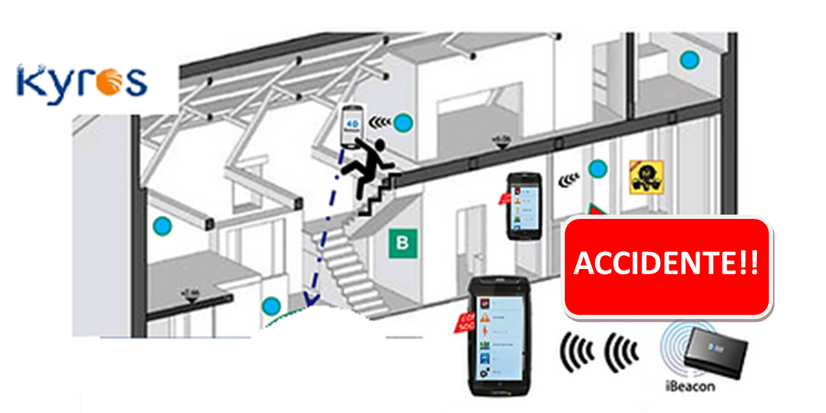
Asset Location via wireless devices with motion or fall detection.

The beacons are installed in the different instances of the dangerous area so that they communicate with the application installed on the ported device by the workers so that Kyros knows where the person is physically inside the building, where a classic GPS system is insufficient.

Kyros combines positioning and communications technology: when assets are in open areas, the system uses GPS technology from locator devices to report location; in the case of indoor assets, restricted access rooms, or even ground floors, the solution is based on the use of bluetooth technologies and / or “radio frequency antennas” deployed in the areas to be covered.

Thus, the system allows locating anywhere, regardless of the environment in which they are located, outside or in hard-to-reach interior areas.

The solution offers different types of radio frequency sensors depending on the specific needs.

Dispositivos_Wireless_BLE

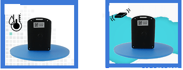
Beacons or active beacons with fall and moisture detection for asset location.

What does the Kyros Location service offer?

Kyros is an easy-to-use, customizable and intuitive web application that allows you to send the person’s location information and record events of the person’s activity, as well as notify an alarm in situations of risk (absence of movement, entry-exit in dangerous areas, etc.) ..

Kyros allows the location and management of all mobile resources, both people, and assets (equipment, instruments and equipment …) and fleets of vehicles that perform field work outside the offices increasing and improving the safety, productivity and profitability of the equipment of work.

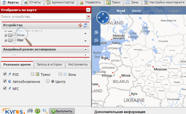
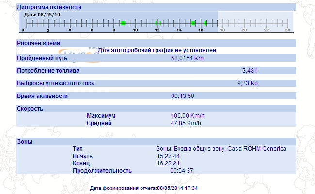
Through the web access Kyros presents on the map or plan and in real time the position of the assets or workers, also offers tools for the planning of work routes and their allocation, being possible to inform in a timely, accurate and real-time way Development of each task. Check if the asset or employee is in the established place or if it follows the route or route defined to avoid displacements, deviations or trips or services not billable to the final customer.

Advantages of Kyros as an asset location system

  • Kyros is a Solution designed specifically for assets or workers in isolated or dangerous environments, such as chemical industries, security, industrial facilities management, oil industry, logistics, construction, etc …
  • Easy to use: usability in risky conditions can save lives, usability that is achieved through the external key easily accessible for use with gloves.
  • Extreme software reliability, verified after thousands of iterations.
  • Long battery life, with several days of autonomy
  • Kyros records the position of each asset or employee to verify maintenance tasks and safety actions
  • Tested in real conditions to detect specific risk events, minimizing false alarms.

Kyros platform

The KYROS® application marketed by Deimos since 2005, is a control and decision support platform capable of monitoring and managing mobile elements of different nature: not only the bracelets of the sick, but also the management of other personnel and assets involved in it (if necessary in later phases): vehicles, medical personnel, assets and points of interest (hospitals, police stations, etc.).

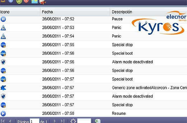
The system categorizes and filters the information so that it is displayed in the most useful and efficient way according to the users and their context, thus the local PC installed in the Residence will show the alerts that occur without the need for an internet connection, while the web access will offer as much information as possible: position, reports, etc.

Kyros Localización Activos

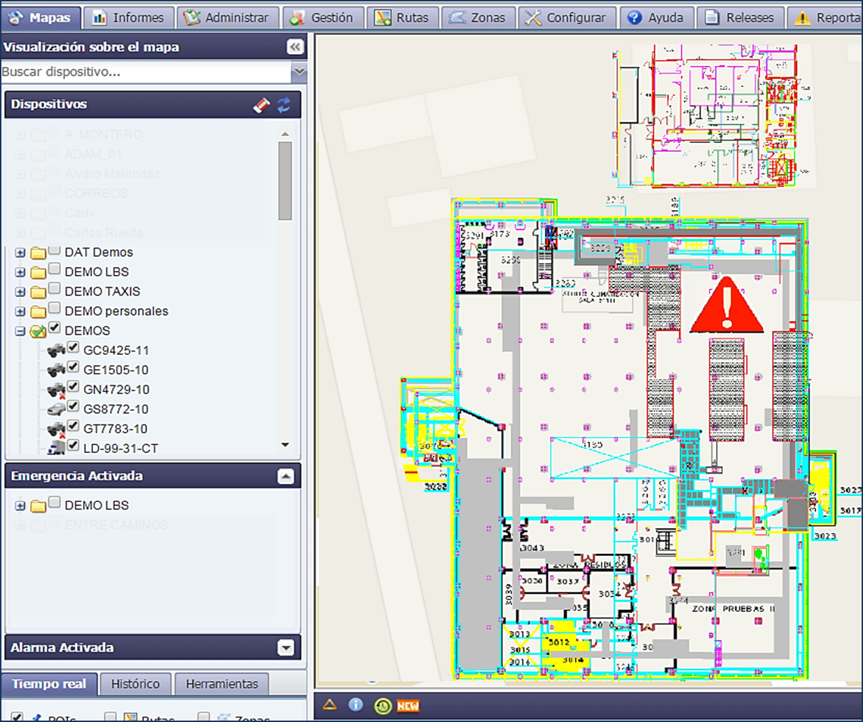
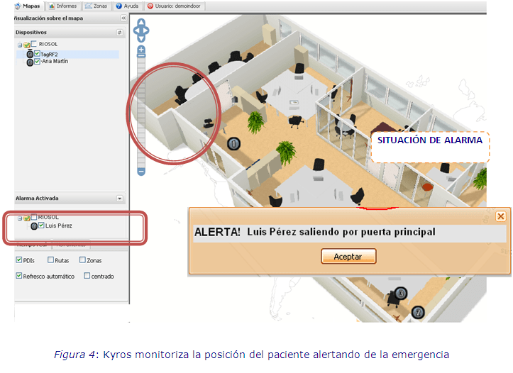
Visualization Maps and Plans in Kyros Platform for Location of Assets inside Buildings

548/5000
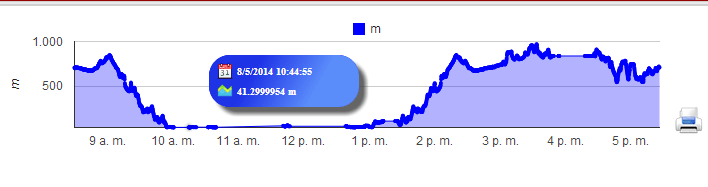
Kyros® allows to visualize on the cartography or planes, the position satellite or bluetooth or radio in real time. It is possible to monitor the location of several devices at the same time, and activate the automatic refresh in the application to facilitate its use to the user.

Kyros® in turn generates or receives movement or zone alerts, for example and sends a notification event that informs the web operator so that it reacts immediately, it is possible to configure the sending of such alerts via push, mail and / or SMS.

Localización en interiores